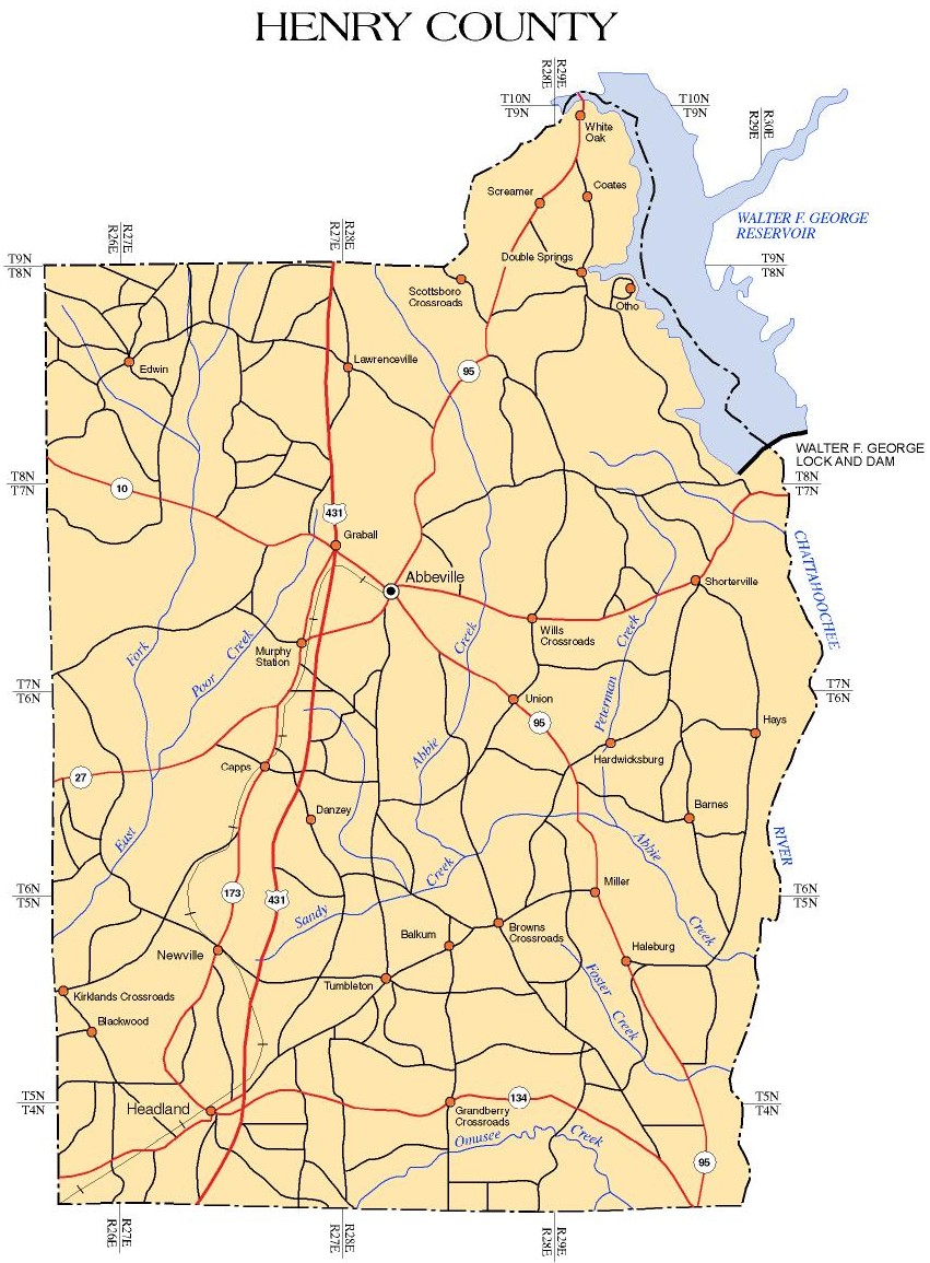
Newton
Originally
in Henry County, Newton is located in Dale County (Southeast
Region), 15 miles northwest of Dothan along Highway 134 near the
Fort Rucker Military Reservation.
Kinsey
Originally in Henry County Named for a
former postmaster, Eliza Kinsey, Kinsey is found in Houston
County (Southeast Region), on the NE outskirts of Dothan along
Highway 431 placing it in the Dothan, Alabama metro area.
Otho
Otho, one of
the lost towns in the county, was a thriving small village in
the early history of that section, about 7 miles north of
Franklin. Stage coaches are said to have passed that way. It was
on the Chattahoochee River road. There were two furnishing, that
is grocery and dry goods stores. A boat landing on the river,
provided means for the merchants to receive merchandise from
Columbus, Georgia and other points along the river. Large
plantation owners in this section traded with the merchants
there who kept good wares and needful merchandise.
Otho drew trade largely from the north east section of Henry
County and south east of Barbour County.
Beginning in the 1880's many of the inhabitants and plantation
owners moved to Columbia, Abbeville, Eufaula, Clayton and
elsewhere.
The Bedell, Averett, McVey, Elias
Thomas, Allen Bizzell, Moses Langston, Hinton Craddock, W. J.
Craddock, Giles Carter, P. M. Thomas, Jesse W. Corbitt,
Lipscomb, Whitmore Price, John and Rebecca Bowden, Nancy Thomas
and her grandchildren, James R. Morris, Henry W. Culver, Albert
A. Norton, William H. Calhoun, George W. Carter, A. S. Hill,
Michael Holmes and Jos. F. Phillips lived at Otho.
Otho began to decline during the 1890's
when prices for farm products were not in keeping with their
cost of production.
The steamboats on the river made trips
from Columbus to Apalachicola twice weekly until 1920.
There was a U. S. Post Office at Otho from 19 July 1854 until 15
November 1905. After that time they called for their mail at
Hilliardsville. Otho was in existent as late as the turn of the
century.
Tumbleton
The settlement called Tumbleton began in the 1890's when Reuben
Shelley and family settled on lands he purchased six miles
northeast of Headland where the old Franklin-Newton and
Echo-Columbia roads crossed. In 1905, the settlement began
replacing Balkum, Alabama as the hub of the surrounding area as
Balkum began to fade away. Mr. John Sanders first claimed lands
in 1856 where Tumbleton stands. The village had several names:
Shelley's Sluice, Shelley's Crossroads, Shelley Town, Tumble
Town, and lastly Tumbleton.
Haleburg
Haleburg is basically a retirement community. It is ideally
located with access to medical, social, shopping, and pleasure
facilities. Fishing and boating opportunities are available on
the Chattahoochee River. Nearby Dothan offers all of the
amenities of a large city. Haleburg is located 15 miles
northeast of Headland and 5 miles from the Alabama-Georgia state
line. The lifestyle of the town is relaxed and easy with no
traffic lights or bustling traffic jams. The neighborly
residents take care of one another's physical and religious
needs at the 2 local churches. It may not be busy here but it is
surely a nice place to live in the area's beautiful rolling
hills.
Headland
Headland, Alabama; a small town located in the southwestern
section of Henry County in the southeastern section of the State
of Alabama! The town was named after Dr. James Joshua Head who
registered his cleared area of 160 acres in Montgomery in 1865;
this land became the largest and earliest settlement, known as
Head's Land. The Post Office created a postmark for the town and
put "Headland" for its name. The town was founded in 1871 and
was incorporated in 1884. People began moving to the settlement,
seeing that its surroundings and strategic location gave way to
a bounteous timber and turpentine industry. As industry
gradually shifted from the lumber base, the area still remained
active in agriculture, having peanuts, cotton, and corn forming
the economic foundation that still exists. Settlers from the
Carolinas and the Virginias brought with them a tremendous work
ethic and a firm will to succeed as they faced the problems and
obstacles in this new, unknown area and way of life.
While agriculture remains important in
its economic base, this doesn't mean that Headland is tied to
the farm.
Our industries include the home of a
furniture manufacturing plant, a baker's yeast production and
distribution facility, a pen and pencil producing company,
construction concerns, trucking lines, professional offices, and
facilities that process and distribute peanuts. It is everyone's
belief in hard work and its rewards that make the city what it
is today; it is that belief that will carry us successfully
forward into the next century. The current population for
Headland is 3,266.
The Blanche Solomon memorial Library is located next to City
Hall on the square and has approximately 17,000 volumes. The
library contains reading areas for all ages, including a room of
area history. It also has 3 online computers available for
public use.
The natural resources of the
area include mining of clays, bauxite, and stone along with
harvesting an abundance of loblolly pines and slash pines. Our
major agricultural products include peanuts, hogs, cattle,
cotton, soybeans, corn, and canola. One cotton gin and 3 peanut
processors operate locally; the closest market for livestock,
soybeans, corn, and canola is in Dothan.
There are 24 churches in and around the
Headland area to serve both the physical and spiritual needs of
almost all denominations; others are found close by in Dothan.
The Headland Observer is the local weekly newspaper that prints
each Thursday. The Dothan Eagle is daily and the Dothan Progress
is a weekly.
Abbeville
The history of Abbeville begins after the early settlers along
the Chattahoochee River on the bottomlands and along the Abbey
Creek and its tributaries were advised by the Indians to seek
higher grounds. These early settlers had experienced illness of
fever, probably malaria, among themselves and their families.
Their land was bought from U.S. Land Office at Sparta in Conecuh
County as early as 1820. They sought higher ground and decided
on that part of the Chunnuggee Ridge that the Indians named "Yatta
Abba", that the settlers knew as Abbeville from 1821. Since the
altitude was 499 feet, the area had perfect drainage. They
heeded this sound advice and began building their log homes in
this healthful area. It began to grow continuously with settlers
coming from the Carolinas, Georgia, and Virginia; 80 percent
were from South Carolina alone. They had been crowded out of
their native states as there was not land enough to go around
among the large families of sixteen or more children.
Once in this county, they found land
that produced abundant crops of cotton and corn and most years
had a very suitable climate. Some of them had come in good
financial condition and added to their holdings by good
management. Many of the jobs held by settlers were not white
collar jobs, but required hands and brains that were needful. Of
the occupations reported were: blacksmith, shoemakers, cabinet
makers, merchants, carpenters, millwrights, planters, spinning
wheel makers, chair makers, hatters, school teachers, surveyors
of land, stockmen, rock and brick masons, to name a few. By
1823, Abbeville was a growing village of substantial residents.
It became the county seat of Henry County in 1833.
Location factors find that Abbeville is
located in the Lower Coastal Plains, an area that runs along the
southern border of Alabama and as far north as the northern part
of Henry County. The Lower Coastal Plains are made up of soils
that respond well to good management, especially fertilizations
and irrigation. A two hour drive from Abbeville will place one
at the Gulf of Mexico's fishing areas and beaches. Lakes and
streams of the Chattahoochee are within 30 minutes, where there
is an abundance of campsites and provisions for boating and
fishing. Hunting advantages further add to the enjoyment of
living in the area.
The Abbeville
Memorial Library maintains approximately 13,000 volumes. An
excellent working relationship exists between the city library
and the regional library, thus providing a rotation of printed
materials and giving a broader base for the library's selection.
This modern library has a spacious meeting room and historical
section that contains records and books of the once-active Henry
County Historical Society.
The local
newspaper is The Abbeville Herald published weekly.
Franklin
Franklin - First Beachhead into
East Alabama
Location: Located near the McKemie Bridge on Alabama Highway 10,
fourteen miles east of Abbeville, Alabama.
Marker Dedication or Erection Date: January 21, 1979
Marker Text
The
frontier village of Franklin was established here by Colonel
Robert Irwin in 1814 on the site of the Indian town of Cheeska
Talofa. It was the first colonial village in east Alabama. Fort
Gaines, Georgia, was constructed in 1816 to protect the early
settlers in this former Creek Indian Nation, West. Twenty-one
blocks were laid off for this promising river port of Abbeville.
This prospective early city never recovered from the destructive
flood of 1888. Erected by the Historic Chattahoochee Commission
and the Henry County Historical Society, 1978.
Lawrenceville
Location: Located on U.S. Highway 431 at
Lawrenceville, Alabama.
Marker Dedication or Erection Date: November 12, 1978
SIDE 1
This
cultural, educational and religious center in east Alabama was
settled in 1823 and named for Joseph Lawrence, prominent
pioneer, farmer, and extensive land owner. A Baptist and a
Methodist Church were established here prior to 1830. The first
settlers of this area came from the Carolinas and Georgia,
crossing the Chattahoochee River at Franklin and squatting here
until land could be purchased in 1828.
SIDE 2: Lawrenceville Academy
The first and foremost educational
facility in east Alabama opened here prior to 1840. It later
became the Masonic Male and Female Institute. This pioneer
school was active for 50 years graduating such outstanding
personalities as Anson West, DDV, Methodist minister,
missionary, author, educator, and William C. Oates, Governor of
Alabama, Colonel C.S.A., General U.S.A., and author. Erected by
the Historic Chattahoochee Commission and the Henry County
Historical Society, 1978.
Hilliardsville
Hilliardsville post office was
established near here on May 18, 1850, with Washington H.
Peacock as its first postmaster, followed in 1860 by John M.
Woods. Discontinued during the Civil War, the post office was
re-established in 1872 with Matilda Thompson as postmistress.
Later appointments were John P. Crawford in 1876, Matilda
Thompson again in 1878, James A. Phillips and Richard Knight in
1882, Mattie R. Bedell in 1883, John C. McLeod, Maggie E.
Johnston in 1884, and William F. Watford in 1887. His son, John
W. Watford served from 1897 until October 15, 1907, when mail
service was transferred to the Abbeville Post Office. Erected by
the Historic Chattahoochee Commission and the Henry County
Historical Society, 1989.

 and
and